


The development of the Avenues
- Feb 19, 2019
- 7 min read
Today we see the Avenues in Hull as a pleasant tree lined series of roads with a great variety of residential architectural styles and enjoying a revival following the post war years of understandable neglect. Consisting of Marlborough, Westbourne, Park and Victoria Avenues with Richmond and Salisbury as cross streets they constituted the original Avenues Conservation Area of 1985.

Westbourne Avenue, Hull, looking east in 1904.
(Courtesy Paul Gibson Hull Then & Now 2)

Westbourne Avenue, Hull, looking east in 2019
(Photo Chris Coulson)
Water, by its coming or going has played a much more important role in the development of this area than might be first appreciated.
Cottingham, founded by the Anglo-Saxons in 600 AD, lay on lines of the springs coming from the Wolds. Although there was much drier productive land in the area draining of a rather wet area called Cottingham Marsh was started by William de Stuteville and Benidict de Sculcoates in 1170s. They organised the digging of drains and field drains which emptied into natural waterways in the area. The first major one was Setting Dyke.

Setting Dyke ran behind the gardens of Victoria Avenue. It was filled in during the 1960s. (Photo Chris Coulson)
Setting Dyke ran eastwards at the side of Queens Road and eventually into the River Hull.

Setting Dyke, now filled in, ran along the south side of Queens Road. (Photo Chris Coulson)
It is not surprising that this drier, new land, should become known as Newlands or Newland Tofts (Tofts = Norse for the site of houses). Because this newly drained land became more productive it attracted tithes and this sparked an ownership dispute between the Rectors of Kirk Ella and Cottingham. In 1262 the Archbishop of York adjudicated this dispute and found in favour of Cottingham.
From the 1600s the land was mainly pasture and meadow and divided into long narrow holdings running more or less East/West. This early land organization probably arose from medieval drainage system which seems to underlie the layout of the present Avenues. The owners rented their land for farming and dairy was an important occupation though later as the pasture area declined keeping cattle for meat occurred as a backstop to milk production.
In medieval times to the 1800's there were several farms and farm houses in the area which was a very important source of butter and milk for the walled town of Hull and this was remarked on by Jonathan Swift (1667-1745). There was still a farm was at the corner of Salisbury and Victoria in 1901 and the Methodist Church on Princes’ Avenue is built over one farmed latterly by William Longhorn.

The land divisions (1837) of the area that became the Avenues. Smith's farm lasted until the 1900s but under different names. (Courtesy of the sister of John Binham Cooper)
The late 1700s saw great changes in Hull and these initiated changes in land ownership and the development of the Newland Tofts area. The construction of the ‘Town Dock’ (later named Queens Dock and now Queens Garden) in 1778, required the removal of the town's north wall and this allowed the town to expand from its previously cramped situation.

The line of the old North Walls. Removed when the Town Dock (Queens Dock) was built in 1779. (Photo Chris Coulson)
Initially Queens Dock, as it became known, was the largest dock in Britain. Other docks at Hull soon followed some considerably bigger than Queens Dock. So water again surrounded the old town but not as a moat as previously but by the docks which came to encircle it.

Queens dock 1779; (H) Humber Dock (now Marina) 1809; (J) Junction dock (now Princes dock) 1829 and (RW) Railway Dock 1846. Other docks were built east and west of here. (Map Wikipedia Commons)
With the old North Wall gone residential developments started on land outside the town. Industry intensified northwards along the river Hull and workers flocked to this area causing overcrowding and poor living conditions and causing a slum, called the Groves, to develop around New Cleavland Street. However, many of the richer merchants and middle class professionals wanted to move out of the old town but more to the north west side.
The Bond Street area was an early residential area and in 1808 Robert Donaldson sold his 20 acre farm land holding in what is now the now area of Ella St and Victoria Ave and moved to ‘Bond St’ (see else where in this blog) thereafter being listed as ‘a gentleman’. The expansion of Hull and the demand for houses for professional people and merchants fuelled land buying and selling.

Map of the Avenues area at the turn of the century. There are still some plots vacant for building. Middle left are three field drains which probably mark the lateral extremities of the earlier strips of farm land (Resources of Chris Coulson)
For example, Henry Broadley (on whose land Marlborough and Westbourne Avenues are built) already owned land but bought more then sold 25 acres to David Garbutt for £8,300. Land speculation had started! Garbutt eventually amassed 320 acres which formed the Westbourne Estate and some (230 acres) later formed The Avenues. By 1879 it seems the roads of the Avenues had been laid out and individual parcels of land were being bought and sold for house building. Some were individual plots while some were longer plots for terraces.
Garbutts’ intention was to create tree lined Boulevards with fountains and to a large extent he did this. Six fountains were built, four in the Avenues and two on Princes’ Avenue. However, they seldom played and four were removed in the 1920s. It might be noted that generally in the country early fountains were for drinking and frequently constructed by temperance benefactors in an attempt to stop labourers quenching their thirst with beer. The drinking fountain in Pearson Park (1864) was made in Glasgow for £32 and identical examples can be found in Bristol, Glasgow, the Isle of Wight, Warrington , even India and the Caribbean!


Left: Drinking fountain in Pearson Park.
Right fountain in Dominica, Caribbean but the fountain has been removed. (Photos Chris Coulson)
The six larger more ornate ornamental fountains were a later manifestation of the Victorian confidence being cast in 1874 by King and Co. of Hull. Among other things this company made wood working planes, exhibited at the Great Exhibition, which are now collectors items. Originating from Wensleydale Henry King's company prospered in Hull only losing its name through a take over in 2004. Kings Market by Holy Trinity Church was their property until 1976. While King and Co made the fountains they were, it seems, erected by Messrs Hebblethwaite & Son and Bruce. They were primarily land agents and although they seem to have done work around the area, some on Princes’ Avenue, they never seem to have ‘broken’ into the Avenues development.

Victoria Avenue fountain. (Courtesy Paul Gibson)
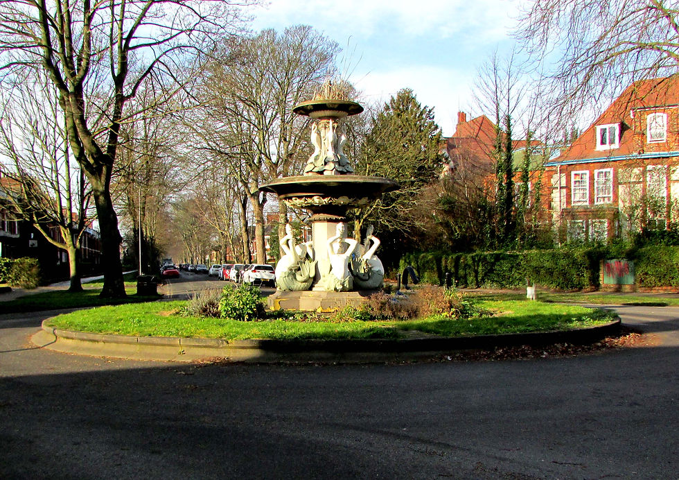
Wesbourne Avenue fountain is the only remaining original one and is Grade II listed. Park Avenue fountain was similar to Westbourne‘s but was destroyed by an allegedly drunk driver much to the great consternation of the residents as he is reported to have said after the crash that ‘it looked better now’. A lynch mob nearly gathered! The Marlborough and Victoria fountains were different to each other (Victoria Avenue's had an octagonal base) and both these were different to Westbourne and Park fountains.

Marlborough Ave. fountain. Turn of the century. Looking west. (Chris Coulson's resources)

One of Princes' Ave fountain and the Methodist church. Miss Winterton of 80 Marlborough Avenue as a child with her Nanny (Resources of Chris Coulson)
Westbourne and Park Avenue fountains are decorated by female water creatures. These are mistakenly called Mermaids were as they seem to be Melusines as they have two tails. Mesulines are freshwater spirits sometimes depicted with two tails or two wings and can be traced back to 14th century Eastern European folk lore.
Westbourne Ave fountain with the 'Hawthornes' far right, a Gilbert Scott Jr house. (Photo Chris Coulson)
Four fountains were removed in the 1920s apparently for road safety reasons. This could indeed be true as in the 1920s a motor cyclist from Withernsea hit the tree which stood adjacent to the post box in Marlborough Ave. He unfortunately died and for some time his damaged motor cycle was left in the garden of 96 Marlborough Ave. I have been told that this accident was why the Marlborough fountain was removed and it is possible that this precipitated the removal of the three others though not all. Indeed these larger fountains by King and Co found their way abroad and one stands in the Botanic Gardens at Christchurch New Zealand.

The fountain in the Botanic Gardens at Christ Church, New Zealand. (Photo Chris Coulson)
Notable houses in Salisbury Street and near by are: Barcombe House (1879, now the NHS Centre) which had a twin next to it (Tower House) but was demolished in 1915.

Barcomb House. Westbourne/Salisbury Street junction.
(Photo Chris Coulson)
Just west on the south side of Westbourne is a long terrace dating from 1879 though examination shows that several of its houses have been modified or at least are different.

A terrace of houses on the south side of Westbourne Ave.
(Photo Chris Coulson)
The five elegant Gilbert Scott (Jr) houses in Queen Anne revival style, which were initially all listed as being in Salisbury Street, are Grade II and date from 1875-79.

Four of the eight Gilbert Scott Jr houses on Westbourne and Park Avenue and Salisbury Street. Far right is Casa carola, centre is Argyle House, left is Stretton House, House far left was un-named. (Photo Chris Coulson)
On the west side Salisbury Street, Park to Victoria Avenues, there is the long terrace of Salisbury Gardens which has Park Villas at its south end and Victoria Villas at it’s north end. These were built 1887-89.

A terrace of houses on Salisbury Street called Salisbury Gardens. (Photo Chris Coulson)
On the north corner of Victoria and Salisbury Street stood Newland Tofts Farm still occupied as a dairy farm in 1901.

The position of Newland Tofts Farm originally belonging to Robert Smith. (Photo Chris Coulson).
Just west of this corner there is a small tenfoot and about half way along it can be seen the grassed over remains of Setting Dyke dug in the 1170s. It continues as a grass strip along the tenfoot on the south side of Ella Street and the south side of Princes’ Road but within living memory was an open drain. This represents the dyke initially dug in the 12th century when the area was first drained.

Setting Dyke between Salisbury Street and Princes' Ave/Queens Road. (Photo Chris Coulson)
Chris Coulson
Aug 2012
Comments